Size: 2,490 Hectares – 5km’s x 2km’s
Ownership: 100%
- Santa Clara is located 70 km northeast of Zacatecas city, 8 km north-northwest of the town of Illescas.
- Santa Clara is the largest of the Company’s Zacatecas-area salars and host to the highest-average grade potassium sediments. This salar has seen a significant amount of historical work from the Geological Survey of Mexico as well as private operators. Some 380 five-metre-deep pits were dug on a 200-metre grid across the entire salar. These pits were sampled every vertical metre and approximately 1900 samples were collected. These samples returned potassium values ranging from 1.25 to 6.61%, with an average value of 4.80%, and lithium values ranging from 17 to 723 ppm with an average grade of 264 ppm.
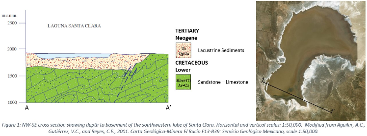
- The size, geology and high potassium content of Santa Clara make this deposit a primary target for potassium and lithium-rich brines at depth. Depth of the basin remains unknown; however, the Geological Survey of Mexico estimates the lacustrine sediments reach up to 300 metre in depth in the southwestern lobe of the salar (see schematic cross section below).
- Sediment sampling is restricted to 5 metre depths in most areas; excellent exploration potential to increase the Mineral Resource at depth and by extending the sampling to the edge of the salar basins where sampling has not taken place.
- Santa Clara salar is the largest salar in the district and hypothesized that it may be the centre point of a regional basin.
- Geophysics results indicate basin depths of 100m to 1,000m which is analogous to similar producing brine aquifers at Clayton Valley, Nevada


